

Three-Layer Milan: An Alternative to Both a Building Freeze and Luxury Towers
The recent exchange between Beppe Sala and Pierfrancesco Majorino over land consumption in Milan has brought back to the fore a question that has never really been settled: how should the city grow over the coming decades? On one side, the emphasis is on halting new construction on undeveloped land and protecting the environment; on the other, the city points to the de-sealing of soil, the creation of new parks and the redevelopment of former industrial sites, backed by data from the Politecnico di Milano.
Joining the debate, Fabio Massa raised a question that deserves an unbiased analysis: why does height continue to be seen as a problem, especially when it makes it possible to concentrate building volumes and free up public space at ground level?
The criticism of a blanket rejection of height has solid grounds. Milan is a municipality with a small territory (about 182 \(\text{km}^2\)) and extremely high demographic and functional pressure. In such a context, limiting density and opposing vertical growth has two direct consequences:
- Pressure on the hinterland (urban sprawl): housing and office demand that cannot be met in the city shifts to the municipalities of the first and second ring, eating up farmland and increasing commuter traffic.
- Stagnation in peripheral areas: imposing strict height limits in outlying districts or on former rail yards often makes any remediation or complex regeneration economically unviable, leaving large areas in their current state of neglect.
At the same time, however, dismissing residents’ aversion to skyscrapers as mere “provincialism” would be an analytical mistake.
The real issue: not architecture, but the economic model
The widespread hostility toward high-rise building in Milan does not stem from a structural phobia of contemporary architecture, but from an economic observation. The towers built over the last two decades (from Porta Nuova to CityLife, up to recent projects in semi-central areas) have been designed almost exclusively for the high-end property market or as headquarters for large multinationals.
With sale prices regularly exceeding €10,000–12,000 per m², these buildings are completely out of reach for the middle class, employees, young couples and students. As a result, vertical growth is perceived not as an opportunity for collective development, but as an accelerator of gentrification and of the displacement of less affluent residents.
The challenge for modern urban planning is therefore to separate the technique of densification from the speculative model: can density and height be used to build a fairer, more accessible and more functional city?
The answer lies in integrated three-dimensional urban planning.
Anatomy of the three-layer city
Instead of treating urban development as a two-dimensional grid on which to place closed volumes, this approach divides the neighborhood into three overlapping, interconnected functional macro-levels:
1. Underground level – The city’s machinery
The underground level hosts all the “heavy” functions, and those that do not need direct sunlight. These include:
- Last-mile logistics: underground hubs for loading and sorting goods, where electric vans and freight vehicles operate without ever reaching street level.
- Parking and heavy traffic: elimination of on-street parking and of the main through-traffic flows at surface level.
- Large-format spaces and services: shopping centers, supermarkets, indoor sports facilities, cinemas, auditoriums and data or waste management infrastructure.
Moving the city’s “operating machinery” underground drastically reduces noise, congestion, local emissions and visual clutter at the surface.
2. Ground level – Reclaimed land
Freed from parking, traffic lanes and driveways, the surface becomes a continuous, fully pedestrian ground once again. The soil is de-sealed and returned to its primary ecological functions:
- Absorbing rainwater and mitigating the “urban heat island” effect.
- Planting tall trees and keeping ecological corridors continuous.
- Public use by residents, free of barriers or traffic hazards.
3. Elevated level – The layered city
Vertical growth does not take the form of the classic isolated tower with restricted access. Instead, it develops through frame structures and elevated platforms linked by skybridges and high-capacity vertical transport (inclined elevators, ramps, urban funiculars).
These suspended decks host:
- Sky parks and public squares at height.
- Schools, cultural facilities and co-working spaces.
- Social housing and cooperative living: affordable housing could be financially sustained by revenue from commercial and logistics concessions on the underground level: a point that, as we will see, needs careful checking.
Precedents and international models
Multi-level integration is not theoretical speculation but a reality already at work in several high-density cities:
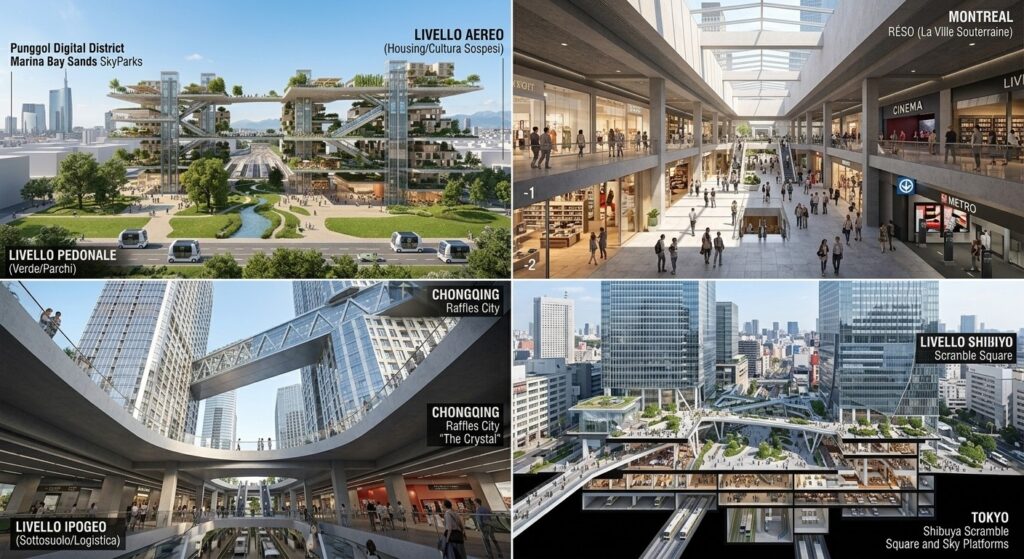
- Singapore (Underground Master Plan): the city-state has formalized an underground master plan to place bus depots, water treatment plants, data centers and logistics hubs below ground. At height, the most relevant case is Pinnacle@Duxton: a public housing (HDB) complex of seven 50-storey towers linked by continuous sky gardens on the 26th and 50th floors; the top one is open to non-residents for an admission fee. The better-known Marina Bay Sands SkyPark, by contrast, links three hotel towers and is a paid attraction rather than an extension of public space.
- Montréal (RÉSO): Montréal’s underground network extends for more than 32 km beneath the city center. Created to cope with harsh winters, it has integrated metro stations, universities, hotels, shopping complexes and offices, showing that pedestrian flows can be managed underground.
- Tokyo and Osaka: in the busiest areas (such as Shinjuku or Umeda), infrastructure is routinely organized on 4 or 5 levels, clearly separating underground logistics, through traffic, elevated pedestrian routes and residential/commercial functions at height.
- Raffles City Chongqing & The Crystal: technical documentation of the horizontal “skybridge” at a height of 250 meters and of its integration with the underground intermodal hub below.
Feasibility in Milan: where and how to apply it
Clearly, infrastructure of this kind cannot be dropped into the established fabric of Milan’s historic center, with its heritage constraints and a subsoil saturated with historical layers and utility networks.
It becomes concrete, both technically and economically, in the large urban transformation areas that are still open:
- Former rail yards (starting with Scalo Farini): areas where the existing railway cuttings and the large earthworks already planned make it possible to build underground levels without digging in built-up surroundings.
- Peripheral transformation areas (Bovisa, San Siro, the urban fringe): sectors where available space and the need for deep regeneration justify long-term infrastructure investment.
The limits to address
A model of this kind must, however, reckon with some concrete limits that determine whether it is really feasible:
- Groundwater and excavation costs: in Milan the water table has risen significantly since the 1990s, with recurring seepage into basements. Every underground level requires waterproofing, mechanical ventilation, fire protection systems and continuous energy use, with construction and running costs well above those at the surface. The idea that underground concessions can fund social housing must therefore be tested against the numbers: the sums add up more easily where excavation is already planned for other reasons, as in infrastructure hubs and rail yards.
- Managing public space at height: elevated squares and parks built by private developers risk becoming public in name only, with opening hours, security checks and filtered access. For the elevated level to truly belong to the city, agreements are needed that guarantee permanent public use, along with clear rules on ownership, surface rights and maintenance.
- Density does not necessarily mean height: compact six-to-eight-storey fabrics, such as Barcelona’s Eixample, reach very high densities without resorting to towers. The tower is one tool among others, useful where large areas need to be freed at ground level, not an end in itself.
A Milan case: Piazzale Loreto (LOC)
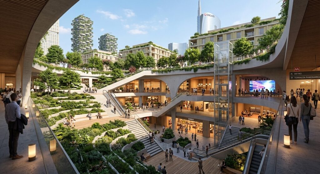
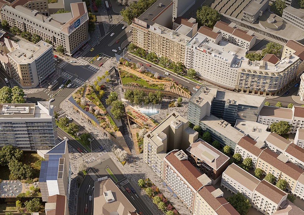
The redevelopment of Piazzale Loreto, known as LOC (Loreto Open Community), is based on a multi-level concept very close to the one described so far.
The plan (developed by Nhood / Metrogramma) aims to turn today’s busy roundabout into a public agora structured on three main levels:
The underground level (below ground):
By opening up and reconfiguring the metro mezzanine and the underground spaces, the project creates a sunken level that works as an amphitheater and a covered extension for events, retail, services and gathering spaces.
The ground level (surface):
Car traffic is sharply reduced, removing the old roundabout to make way for a large pedestrian and cycle square, rich in greenery, trees and water features.
The elevated level (roofs / terraces):
The new buildings framing the square are designed with roof gardens and accessible terraces open to the public, visually and physically connected to their surroundings.
Although it arose within an existing road junction, rather than on a disused site such as a rail yard, the Piazzale Loreto project applies the same principle of functional layering and three-dimensional public space: taking space away from cars and giving it back to people, below ground, at street level and at height.
The construction site has run into delays and red tape, but the underlying concept remains that of a layered square.
Conclusion
Remaining split between a “nostalgic” view that would freeze Milan at last century’s building heights and a “speculative” one that leaves vertical growth entirely to luxury real-estate funds narrows the public debate.
The real challenge for politics and for future administrations is not deciding whether to build “up” or “down”, but having the technical and conceptual ability to design urban density in three dimensions, putting architectural innovation at the service of social inclusion and quality of life.
A concrete first step could be a pilot project on one of the former rail yards: a share of social housing locked in over time, elevated spaces that are public by binding agreement rather than by revocable concession, and a transparent economic balance sheet for the underground level, showing whether, and to what extent, its concessions can really support affordable housing.
From the same category
- 6BX7-GT: SPICE Model, Koren Fitting and Validation
- The Koren triode model: theory, parameters and limitations
- From datasheet to SPICE model: Koren fitting of the 6BX7-GT
- Triode operation, characteristic curves, and operating point
- From Visible Light to Infrared: A Brief History of the Remote Control
- How an IR Remote Control Works: Carrier, MARK, SPACE and NEC Protocol